 "Every day you can run is a good day." - JT
As part of my b-day celebration, I had planned to run a 50K race up in Tahoe along some of the most beautiful alpine scenery in western Nevada. But as I am seemingly prone to do, I over-trained, rested little and wound up with a minor hip/low back injury that prevented me from starting the race. It was a tough decision to not start the race, but I think it was a sound one that will save me many, many months of pain and rehab.
The good news is that I caught it EARLY (like within the first two weeks)…whereas before I would have run through it for at least a month, and in this case, probably through the race. ;) Maybe I am getting wiser with old age! The even better news is that, after less than two weeks of NO running and intense physical therapy (or what I lovingly refer to as “pain therapy”), I am already running again. It’s very slow…think snail pace…and only a mile or two at a time....but it's running and as my dad (aka JT) always says, "Every day you can run is a good day." What a smart man!
The good news is that I caught it EARLY (like within the first two weeks)…whereas before I would have run through it for at least a month, and in this case, probably through the race. ;) Maybe I am getting wiser with old age! The even better news is that, after less than two weeks of NO running and intense physical therapy (or what I lovingly refer to as “pain therapy”), I am already running again. It’s very slow…think snail pace…and only a mile or two at a time....but it's running and as my dad (aka JT) always says, "Every day you can run is a good day." What a smart man!

With my speedy rehab, JT and I set out to do a hike in lieu of my bday ultra run. We naturally chose one of my favorite sections of the Tahoe Rim Trail (TRT). (NOTE: JT is a PT – physical therapist – but does not treat me. And my real PT, whose initials are also AT, was none too thrilled that both JT and I thought it was a “good idea” for me to do a 17-mile mountain hike while still “injured”…puh-leaze!) While only half the 50K distance, it would still be challenging…especially for me, as I prefer to run not hike. In fact, I had done this 17-mile section multiple times before, but almost always as an out-and-back 34-miler RUN from our house in Incline Village. So to HIKE it, in reverse, one-way only, was way beyond anything I’ve ever done. I do like a good challenge.
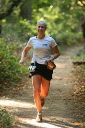
(ABOVE: JT and I at the "starting line" at Spooner Lake.)
So after a hearty breakfast of mochas, bear claws and danishes (I did mention it was my bday weekend…so b-day calories don’t count, right?), my mom drove us to our starting point at Spooner Lake (elevation about 6500’). With Salomon daypacks brimming with slushy Gatorade, Power Bars and trail mix, we bid adieu to a mother who couldn’t get over the fact that we didn’t have a “survival pack” handy on us. (First aid kits apparently weren't enough for her.)
One of the reasons I love this 17-mile section is that you get to see and do it ALL. The first 5-6 miles are a good climb up to about 9200’ where the trail literally drops you off on a peak overlooking Marlette Lake – a true blue alpine lake nestled along the backside of the mountains surrounding Lake Tahoe. I had run this section last year in the first week of June and there was 3-4 miles of snowpack. But this year (3 weeks earlier), there was only about 15 feet of patchy snow -- a foreboding sign of impending drought in NorCal? Time will tell. But, as my mom would say, man a living, was it gorgeous at Marlette!
 (Left: Coming over peak with Marlette Lake in front of us.)
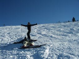
(Below: While JT tried to find a “safe” and sturdy way around a patch of trail that was no more, I climbed above like Spiderman and practiced my bouldering skills (which was also a good way for me to gauge my right hip pain/weakness).

 After a mile walk around Marlette, the trail spits you out at the top of the Flume Trail – recently rated as one of the nation’s top ten mountain bike trails. For the next 4.5 miles, the single-track trail follows right along the mountainside facing Lake Tahoe. On average, the trail is about 3 feet wide and there's quite a STEEP drop-off should you carelessly miss a step. These 4.5 miles are all flat, so JT and I decided to do a little casual running, just to see how we felt running at 8,000' and to again gauge my hip pain. Um, excuse me JT, but I’m running along a ridgeline at 300 feet above one of the most beautiful pieces of mountain lake scenery known to mankind, not to mention I'm feeling light and loopy from the high altitude. So yeah, I’m going to feel great! I'm on TOP of the world!!
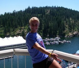
  (Left: On top of the world above Sand Harbor.)
(Below: Me on a rock jetting out over a cliff.)
Along the Flume Trail, we chatted about everything from the upcoming presidential elections to the egregious selfishness of pro basketball players and the resilient patience of NBA coaches for putting up with the such immature players. I'd walk out as close to the edge on the cliffside, and JT would hug the mountainside; he said he'd promise Mom that not only would we return, but we'd return with all body parts still attached. A Thomas always keeps his promise.
 Overlooking the crystal blue waters of Sand Harbor, I really did feel like I was standing on top of the world. That was, until we reached mile 11.5 at the top of the TRT known as Tunnel Creek (just below Twin Lakes, which were already dry this early in the season -- double yikes!). That's when I stupidly looked down at my watch and saw that we were almost 3 hours into our trek. Growing tired and cranky, I thought to myself, I would be done by now if I was running! In long runs/hikes, sometimes you just reach a point where you want to be done - finis! And I had definitely reached that point. It was going to be a good 90 minutes to do the last 5+ miles and so I had to find a way to suck it up and forget about running.
 The next 3 miles were downhill and hiking this can be more difficult than hiking up because gravity wants to pull you down faster than your legs can walk (and running downhill was painful on my hip). With the gorgeous views of the lake it wasn't too hard to lose myself in thoughts of how lucky I am to be able to go out and do this type of activity, especially in such beautiful places -- and with one of my heroes, JT. Days like these, I revel in the saying, "It doesn't get much better than this!"
 (Left: JT walking downhill faster than moi! Not bad for an old guy!)
We reached the famous Ponderosa Ranch, threw around ideas about what they should do with the land and bantered about the excessive over-development of this pristine national forest (I being the ever conservative environmentalist, while JT wanting to "Keep Tahoe Blue" but still happy about the Starbucks that appeared in Incline about two summers ago.) Just 2 miles to go now and we were finally on the homestretch - literally our homestretch - a 2-mile route that we run countless times during the year - rain, sun, snow and ice. The route runs one mile along Lakeshore Drive (right along the Lake Tahoe shore, duh) and past the extravagant yet gorgeous multi-million dollar mansions, past the restored Old Tahoe style Hyatt (the one real hotel in Incline Village) and then uphill 1 mile, along the golf course, to our cabin -- where we were greeted enthusiastically by Mom, Arlo and Teddy.

AT & JT conquered this section of the TRT. But never ones to get too excited about our feats, AT is already planning to conquer yet another section of this famed 165-mile trail on our next Tahoe adventure. 10% of the way there and excited about the remaining 90% - whether running or hiking! It's going to be an awesome Tahoe summer for sure. And truly, it doesn't get much better than that!
Challenge yourself today!
Alikona
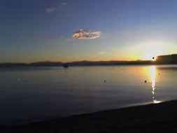
(View from above flume trail. Note the picturesque clouds.)


1 comment:
The TRT looks like an idyllic place to run and hike everyday, especially with your dad! I think b-day calories count, but you know you burned at least 1700 right? I say eat more run further, run less eat less. Nice photos.
Post a Comment